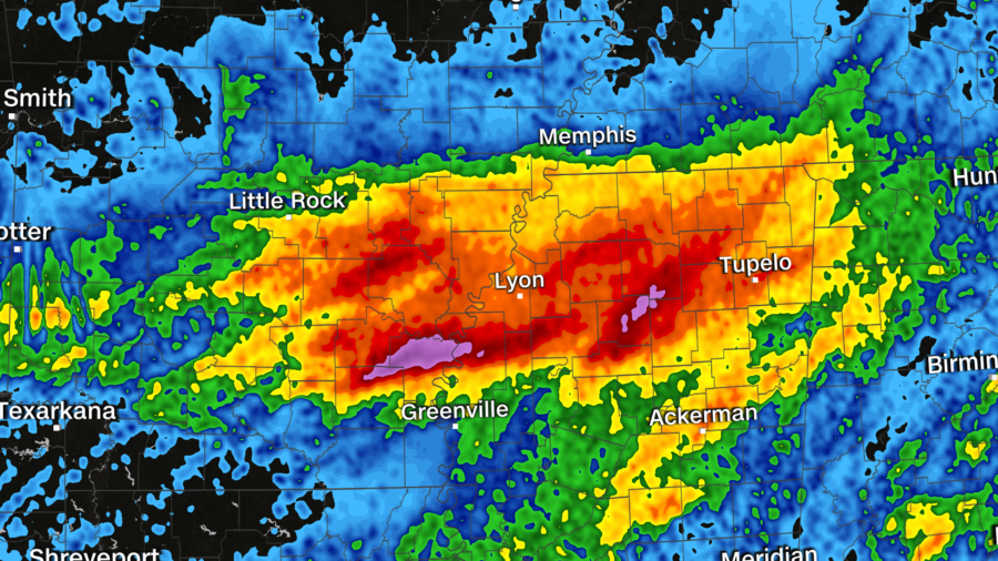
It’s been nothing short of a deluge across the Mid-South in the last 48 hours, and nothing is changing Wednesday.
“No sugar coating the short term forecast,” said the National Weather Service (NWS) office in Little Rock, Arkansas.
The highest risk for excessive rainfall is forecast for the second day in a row. Then another round of rain is likely Thursday before a drying trend kicks in Friday.
“Rainfall and flash flooding will continue to be a major concern, following an extreme day of rainfall across the southeast Delta region,” the weather service said of the Wednesday forecast.
Another 2 to 5 inches of rain was forecast Wednesday for parts of eastern Arkansas and northern Mississippi, where the ground is already saturated. And more rainfall could mean flash flooding.
Some residents in Lafayette County, Mississippi, were briefly asked to evacuate their homes. The county’s fire department requested Wednesday afternoon that people who live in an area outside Oxford leave because a levee on Lake Tara could breach.
The Mississippi Emergency Management Agency said that though the levee has not yet breached, a sinkhole is forming. Firefighters are pumping water from the lake to relieve pressure from the levee, the agency tweeted.
Several hours later, the fire department said residents could return home.
Flash flood watches and flood warnings were in effect for Mississippi and Arkansas, with potential river flooding as well.
“The greatest concern is expected to be across southeastern Arkansas and northern Mississippi, where a High Risk of excessive rainfall is in effect for Wednesday and Wednesday night,” said the weather service’s Weather Prediction Center.
“This region has been hammered by torrential rain and flooding over the past 1 to 2 days, and the additional 2 to 4 inch rainfall totals on saturated ground will greatly increase the flash flood threat,” the center said.
Rainfall accumulations of 8 to 10 inches were seen Tuesday across the region, and some areas may have gotten more. Some parts of Arkansas have estimated a foot of rain over the last few days, and flash flooding has been significant.
Rowher, just west of the Mississippi River, got more than 9 inches of rain, making it the rainiest June day of anywhere in Arkansas since 1959.


