It’s been almost two years since Washington has had a snowfall greater than 1 inch, but that could change drastically by Monday. The city is under a winter storm watch from Saturday evening until Sunday evening, with 5–10 inches of snow possible.
“Forecasting snowfall amounts in the nation’s capital is rarely easy, but confidence is increasing that the D.C. area will see a significant snowfall developing on Sunday and lasting into Monday,” says CNN meteorologist Taylor Ward.
A big winter storm is in the works that could bring the nation’s capital as much as 10 inches of snow. This would end the 709-day streak that Washington has gone without a snowfall greater than 1 inch.
“The only other time this has happened was a 788-day streak that ended in 2013,” says CNN meteorologist Brandon Miller.
The Storm’s Track
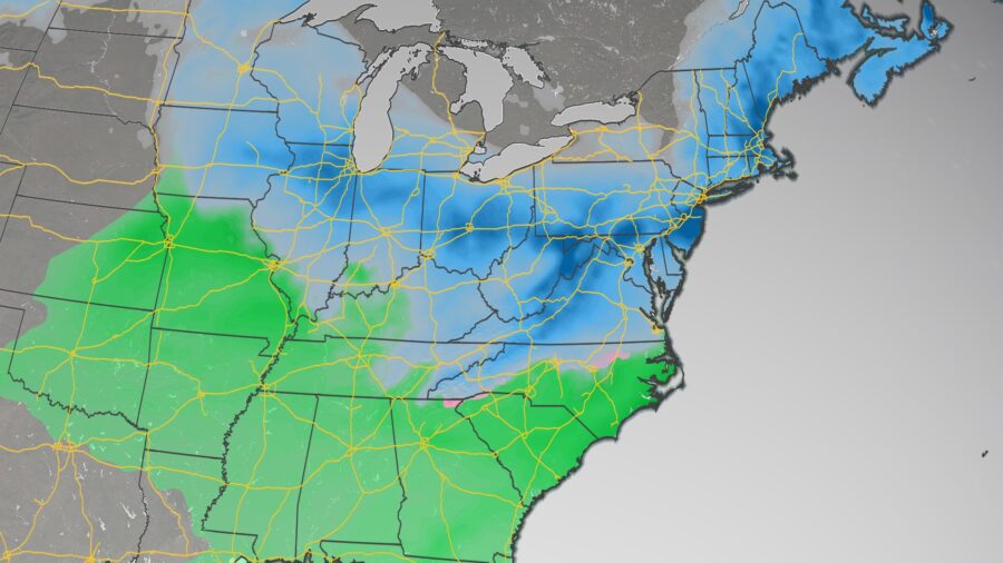
Saturday morning, more than 90 million people are under winter weather alerts from North Dakota to North Carolina.
Throughout the day, the storm system will bring heavy rain to the country’s midsection. Salt Lake City may also see a few lingering snow showers Saturday morning.
Areas farther, east such as St. Louis and Springfield, Illinois, will see more of a rain/snow mix through Sunday. Exactly how much snow will stick to the ground remains uncertain.
One week after areas of Iowa were pummeled by snow, the Hawkeye State could see a few additional inches this weekend.
“Unlike the last system, this one will contend with warmer temperatures that will yield periods of rain, snow, and wintry mixes depending on where you are in the state,” said the Des Moines office of the National Weather Service. “The best chances for accumulating snowfall will be areas east of I-35 and along/north of I-80.”
Winds will kick up Saturday along the Central Plains, which will increase fire threats for portions of Kansas, Oklahoma, and Texas.
Much of the Mississippi River Valley will receive heavy rain and portions of the Midwest will get snow. Chicago is under a winter storm warning through Sunday morning, with 5–9 inches of snow possible. Along with the snow, 30 mph winds are expected across the region, which could result in dangerous travel conditions.
The best chance for heavy snowfall appears to include areas of northern Illinois, Indiana, and Ohio, as well as southern Wisconsin.
The storm will continue to the East, dumping rain on the Southeast and snow on the Ohio Valley before heading East and creating a concern for ice across portions of North Carolina, Virginia, and West Virginia.
A Developing Nor’easter
“Snow will move in from southwest to northeast late Saturday night and early Sunday morning, with snow likely widespread by mid-late morning Sunday,” said the weather service office in Baltimore and Washington.
By Sunday afternoon into Monday, there is the potential of a changeover to sleet and freezing rain.
With the storm system still a few days away, there is still some uncertainty in the forecast about how much snow will fall in the Northeast.
“There seems to be a consensus amongst forecast models that moderate to heavy snow will occur from portions of Virginia to Pennsylvania and New Jersey, but there continues to be some uncertainty on the exact track of the low pressure Monday into Tuesday,” Ward said. “This will have a significant impact on how much snow falls from New York City into New England. A storm system that tracks parallel to the coast would provide greater snowfall, while a more eastward track out to sea would limit snow totals in New England.”
That could make the difference in places like Boston and New York City seeing 4 inches of snow or a foot.
Philadelphia’s weather service office is forecasting more than 6 inches of snow with gusts of wind as high as 45 mph “creating significant blowing and drifting snow.”
In its forecast discussion, the office also noted that the storm is forecast to be an abnormally long storm with 36 or more hours of snow and wintry precipitation, and that the highest snow totals and rates will likely not be realized until late Monday.
The weather service office in Boston hinted Friday at the storm and its possible effects.
“There is the potential for a significant winter storm later Mon into Tue,” the Boston office said on Twitter. “If this storm materializes significant snow accumulations would be possible for some along with a period of strong winds & coastal flooding along the eastern MA coast.”
The storm will then push off the coast by late Tuesday.

