Severe weather season is ramping up as the chance for more strong storms threatens parts of the South this weekend, on the heels of Thursday’s deadly tornado outbreak.
Around 70 million people could face severe storms this weekend, including Nashville, Memphis, Little Rock, Atlanta, Charlotte, Raleigh and Washington, DC.
“Conditions, like we will have on Saturday and Sunday, can fool people. You look at the forecast and say, ‘Well that’s not as bad as Thursday,’ and that is true,” said CNN meteorologist Chad Myers. “These high risk days we’ve seen this year inadvertently alter your expectations. Will we have the same risk as yesterday? No. Will we still have some tornadoes, hail and wind? Yes.”
While the tornado risk may be lower this weekend, it only takes one to hit your home to make this a dangerous, damaging event.
A new weather disturbance moving in from the west will introduce showers and thunderstorms beginning Saturday morning.
Saturday
The Storm Prediction Center (SPC) has a level 3 out of 5, “enhanced risk” for severe storms for portions of Arkansas, Tennessee and Mississippi. There is also a risk, albeit lower, from central Illinois through northern Texas and northern Georgia Saturday into Saturday night, encompassing about 30 million people.
“All hazards are possible including large hail, damaging wind and tornadoes,” said the SPC.
A few rounds of showers and storms are expected during the day Saturday across the mid-Mississippi River Valley. The severe weather threat will be most significant overnight, however.
Overnight severe weather, especially when tornadoes are involved, is most dangerous. During the day, it’s not as difficult to spot a tornado, but at night it is rather impossible.
Storms will begin to develop Saturday evening across the southern Plains and Midwest, and they will track eastward into a more favorable environment for impactful storms.
Current model guidance is suggesting a line of thunderstorms developing Saturday night, spanning from the Ohio River Valley to near the Gulf Coast. Wind and hail will be the main threats, but tornadoes are also expected with some storms.
Some of this rain will be heavy. The Weather Prediction Center is warning that flash flooding could be possible: “there will likely be localized to scattered flash flooding centered across the Tennessee Valley.” Rainfall totals could exceed 4 inches in this region.
Sunday
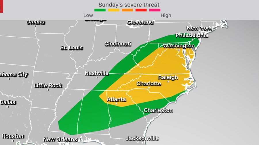
The threat then shifts toward the East Coast for Sunday, with about 57 million people at risk for severe storms.
“Damaging wind will be the main threats, but a few tornadoes and some hail will also be possible before the front moves offshore during the evening,” said the SPC about Sunday’s threat.
This will span from southern Pennsylvania and New Jersey through the Carolinas and back into Mississippi. The greatest risk will be from Delaware through northern Georgia, where a level 2 out of 5, “slight risk” is currently in place. This “slight risk” includes cities like Washington, DC; Baltimore; Richmond; Charlotte and Atlanta.
A few showers could be possible near the East Coast Sunday morning, but the timing of these severe storms will not be until Sunday afternoon into Sunday night. Temperatures will be in the 70s and 80s—this warm and moderately moist environment helps fuel thunderstorms. Meanwhile, in the Northeast there will be widespread, cooler rain.
Early next week, a new storm system will form near the Gulf Coast and track up toward the Northeast. It is unclear whether there could be severe storms associated with this system but more rainfall is certain.


