
Something unexplainable appeared on the weather radar on Dec. 10 in Kentucky.
Around 2:50 p.m. on Dec. 10, the crews at the National Weather Service office in Paducah saw something peculiar in the Southern Illinois region.
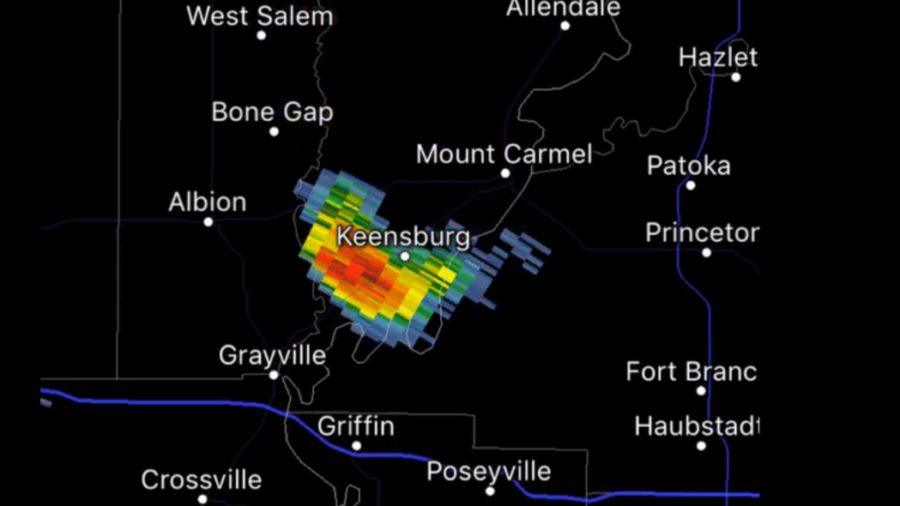
Color-coded from blue to red, the radar image seemed to suggest a strong storm surrounded by clear-blue sky. Imagine this: you are looking out of your window and find that while there’s not a drop of rain in your garden, your neighbors’ garden is raining cats and dogs.
The clear sky was correctly reflecting the actual weather situation—a mild day with light winds and temperature in the 20s.
As shown in the 6.5 hour time loop recording posted by NWS Paducah’s Twitter account, the unexplainable stretch of colors originated in far southern Richland County, Illinois, in a rounded shape and moved southwards towards western Kentucky as it elongated.
About half an hour earlier, the NWS Paducah published a post saying that they were sure that it was not a matter of perception, and asked people in the area to look for anything overhead or falling.
The NWS Paducah’s posts about the strange radar pattern received various responses from Twitter users; while some expressed their surprise and confusion, others gave various theories—from aliens, Santa, meteorite, a flock of birds and chaff.
"Upper level winds can be much stronger this time of year. However, winds aloft late Monday averaged 10 to 15 mph from the north northwest. That would explain the rather slow movement and slow dispersion of the chaff debris," wrote NWS Paducah in a post.
However, even the most likely explanation was questioned.
“Pretty crazy to have a chaff stream in the air this long and an area this big. Makes me think this is something different,” wrote Chris Conley in a Twitter response.
“Information from a pilot appears to confirm that chaff was the mysterious radar echo that traversed #tristatewx late Monday afternoon/evening. Pilot was told by EVV Air Traffic Control that chaff was released by a military C130 northwest of Evansville,” wrote Wayne Hart in a tweet.
Wayne Hart added that the chaff was from a military exercise in a later response.
Despite the confirmation, several Twitter users continued to question the real reason behind the formation of the radar echo.