


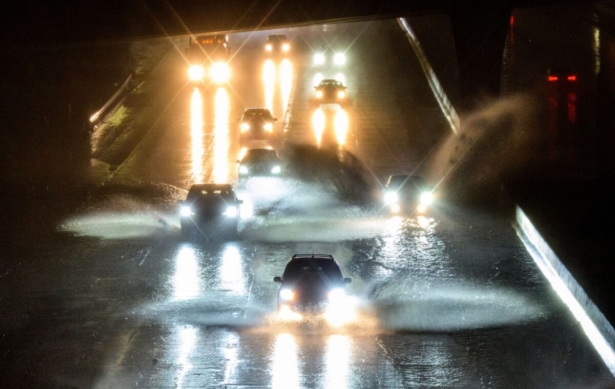
The National Weather Service said early Thursday that a “significant storm” has arrived in California, bringing heavy rainfall, flooding with debris flows, and landslides that are expected to impact the state throughout the day, while local media reported that what has become a “bomb cyclone” has led to the death of at least one person.
The powerful low-pressure storm system strengthened rapidly on Wednesday to became what’s known as a “bomb cyclone,” which is a low-pressure area that intensifies by 24 millibars within 24 hours.
After gaining strength offshore, the bomb cyclone slammed into the California coast on Wednesday night, bringing hurricane force wind gusts and knocking over a tree in Sonoma County, which fell on a home and killed an infant, according to ABC News.
A 19-year-old resident of Fairfield, which is in the San Francisco Bay Area, was killed on Wednesday when the vehicle she was driving hydroplaned on a partially flooded road and slammed into a utility pole, CBS reported.
Nearly 190,000 homes and businesses were without power early Thursday, according to PowerOutage.us.
Officials have ordered evacuations in some parts of California, including a high-risk coastal town where mudslides killed 23 people in 2018.
“We anticipate that this may be one of the most challenging and impactful series of storms to touch down in California in the last five years,” said Nancy Ward, the new director of the California Governor’s Office of Emergency Services.
San Francisco Mayor London Breed said at a news conference that the city was “preparing for a war,” while crews cleared clogged storm drains, tried to move homeless people into shelters, and passed out emergency supplies and ponchos to those who refused to go.
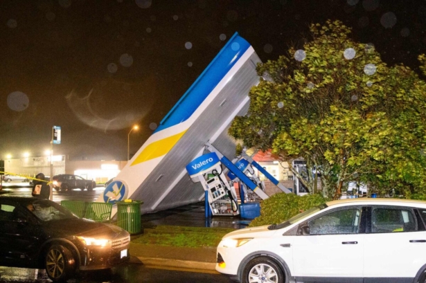
Powerful winds gusting to 85 mph forced the cancellation of more than 70 flights at San Francisco International Airport and knocked over power lines and trees.
Warnings
High wind warnings were in effect along the Bay Area and Central Coast regions through at least 10 a.m. ET on Jan. 5, according to the NWS Forecast Office San Francisco, with valley wind gusts up to 50 mph and mountain area gusts as high as 70 mph.
“Tree limbs could be blown down ad a few power outages may result,” the San Francisco NWS forecast office said. “Use caution if near the coast for winds will be strong.”
High surf warnings were in effect through Thursday until at least 3 a.m. ET on Friday, with expectations of very large breaking waves as high as 30 feet, affecting the entire central California coastline.
“Dangerous swimming and surfing conditions,” NWS Forecast Office San Francisco said in an alert, which urged people to stay off coastal rocks and avoid steep beaches, and “never turn your back to the ocean!”
A flood watch is in effect through Thursday afternoon, with warnings of rapid rises in rivers and creeks, widespread flooding, multiple mud and landslides, and impassable roads.
The latest short-range forecast from the NWS Weather Prediction Center, issued shortly after 3 a.m. on Jan. 5, warns of excessive rainfall over parts of California on Thursday and Friday, with a “powerful atmospheric river” continuing to stream moisture through much of the state on Thursday.
“Extremely heavy snow rates above 3 inches per hour are nearly certain above 5000 feet, which will lead to dangerous, and at times impossible, travel in the mountains of Northern/Central California,” the weather alert states.
Rain falling at a rate of over one inch per hour could lead to rapid water rises and mud and rock slides, with coastal areas of California and the Sacramento Valley being most at risk.
“Considerable flooding impacts are likely” on Thursday, the NWS Weather Prediction Center said.
“Heavy rain will create mainly localized areas of flash flooding, with urban areas, roads, small streams, and burn scars the most vulnerable,” it added, warning that widespread wind gusts over 50 mph coupled with water-logged soils make trees more susceptible to getting blown over.
The stream of moisture will flow into Northern California on Friday, producing heavy rain and prompting the Weather Prediction Center to issue an excessive rainfall warning over southwestern Oregon and Northern California into Saturday morning.
Snowpack
Meanwhile, the snowpack covering California’s mountains is off to one of its best starts in 40 years, officials announced Tuesday, raising hopes that the drought-stricken state could soon see relief in the spring when the snow melts and begins to refill parched reservoirs.
Roughly a third of California’s water each year comes from melted snow in the Sierra Nevada, a mountain range that covers the eastern part of the state. The state has built a complex system of canals and dams to capture that water and store it in huge reservoirs so it can be used the rest of the year when it doesn’t rain or snow.
Statewide, snowpack is at 174 percent of the historical average for this year, the third-best measurement in the past 40 years. Even more snow is expected later this week and over the weekend, giving officials hope for a wet winter the state so desperately needs.
The storms in California still aren’t enough to officially end the drought, now entering its fourth year. The U.S. Drought Monitor showed that most of the state is in severe to extreme drought.
“We know that it’ll take quite a bit of time and water to recover this amount of storage, which is why we don’t say that the drought is over once it starts raining,” said Jeanine Jones, drought manager for the California Department of Water Resources.
Jack Phillips and The Associated Press contributed to this report.
From The Epoch Times