
Hurricane Ida is looking eerily like a dangerous and perhaps scarier sequel to 2005’s Hurricane Katrina, the costliest storm in American history. But there are a few still-to-come twists that could make Ida nastier in some ways, but not quite as horrific in others.
“The main story with Katrina was storm surge damage, and over a vast area. The main story with Ida will be a combination of wind, storm surge, and fresh water flooding damage,” said meteorologist Jeff Masters, who flew hurricane missions for the government and founded Weather Underground.
What could be different is crucial though: direction, size, and strength.
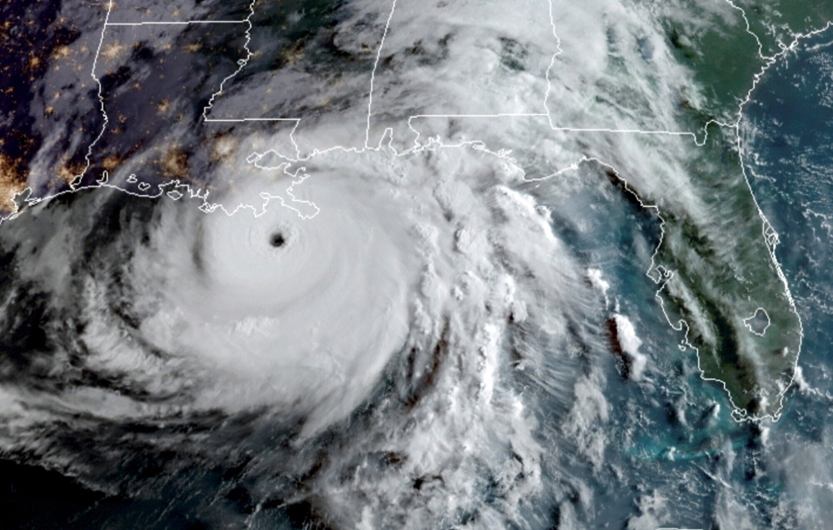
Ida made landfall as a Category 4 storm with 150 mph winds—just shy of Category 5—on the same calendar date, Aug. 29, as Katrina did 16 years ago, striking the same general part of Louisiana with stronger wind speed, after rapidly strengthening by going over a similar patch of deep warm water that supercharges hurricanes.
Ida’s northern eyewall made landfall near Port Fourchon, Louisiana, at around 12:50 p.m. ET, according to the NHC. The hurricane has maximum sustained winds of 150 mph and a minimum central pressure of 930 millibars.
At 2 p.m., the NHC said the storm made its second landfall near Galliano, Louisiana, with maximum sustained winds of 145 mph.
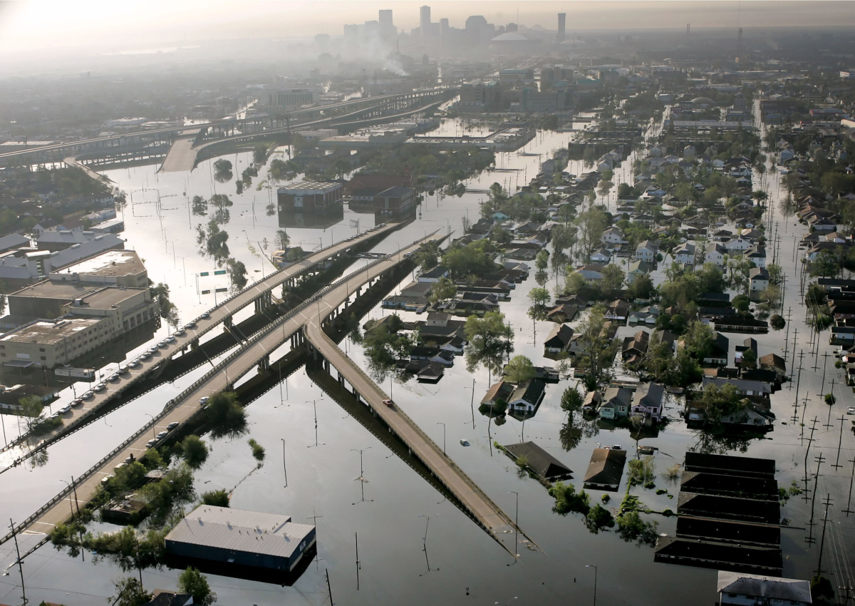
Katrina weakened quite a bit before landfall, striking Louisiana as a Category 3 storm with 127 mph winds.
“This has the potential to be more of a natural disaster whereas the big issue in Katrina was more of a man-made one” because of levee failures, said University of Miami hurricane researcher Brian McNoldy. Levee failures pushed Katrina’s death toll to 1,833 and its overall damage to about $176 billion in current dollars, and experts don’t expect Ida to come near those totals.
Different Direction
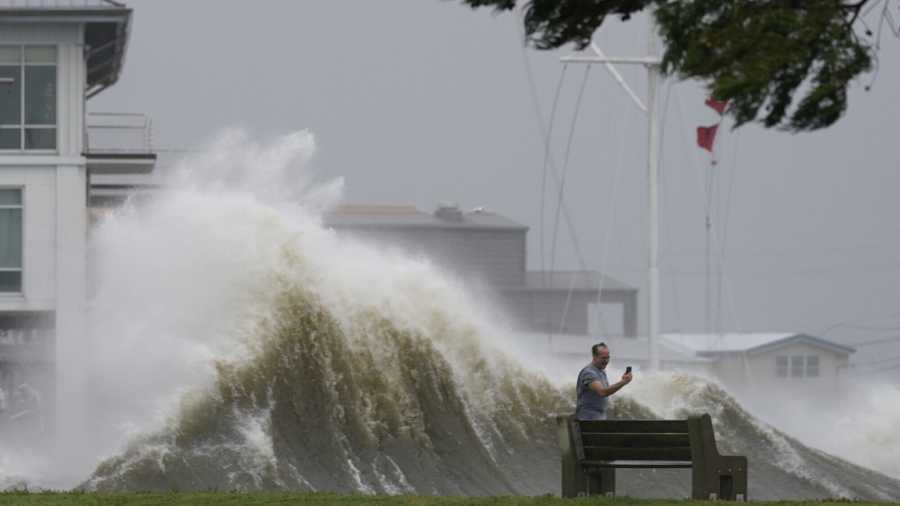
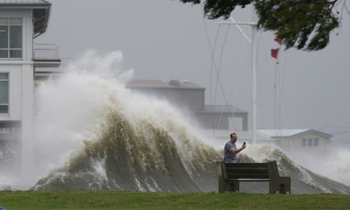
Ida is coming to the same general place from a slightly different direction. Several hurricane experts fear that difference in angle may put New Orleans more in the dangerous storm quadrant—the right front part of a hurricane—than it was in Katrina, when the city was more devastated by levee failure than storm surge. Katrina’s northeast quadrant pushed 28-foot (8.5-meter) storm surges in Mississippi not New Orleans.Ida’s “angle is potentially even worse,” McNoldy said. Because it is smaller "it's not going to as easily create a huge storm surge ... but the angle that this is coming in, I think is more conducive to pushing water into the lake (Pontchartrain).”
That northwestern path of Ida not only puts New Orleans more in the bullseye than it did in Katrina, but it also more targets Baton Rouge and crucial industrial areas, Masters said. He said Ida is forecast to move through “the just absolute worst place for a hurricane.”
After making landfall, Hurricane Ida was churning through the far southern Louisiana wetlands, with the more than 2 million people living in and around New Orleans and Baton Rouge up next.
“It is forecast to track over the industrial corridor between Baton Rouge and New Orleans, which is one of the key infrastructure regions of the U.S., critical to the economy,” Masters said. “You’re probably going to shut down the Mississippi River for barge traffic for multiple weeks."
Meteorologist Steve Bowen, head of global catastrophe insight at the risk and consulting firm Aon, said the impact will be felt beyond coastal areas.
“We’re certainly looking at potential losses well into the billions,” Bowen said.
Size Matters
The difference is size is not just physically huge, but it matters for damages. Storms that are bigger in width have larger storm surge because of the broader push of the water.Ida “is not going to generate the huge storm surge like Katrina did, it’ll have more focused storm surge like (1969’s) Camille,” Masters said.
But larger-in-size storms are often weaker, Bowen said. There’s a trade off of intense damage in a smaller area versus less damage, but still bad, in a wider area. Bowen and Princeton University’s Gabriel Vecchi said they don't know which scenario would be worse in this case.
Rapid Intensification
Ida late Saturday and early Sunday feasted on an eddy of what’s called the Loop Current, going from 105 mph winds to 150 mph winds in just eight hours. The Loop Current is this deep patch of incredibly warm water. It takes warm water off the Yucatan Peninsula does a loop in the Gulf of Mexico and spins up the eastern edge of Florida into the Gulf Stream. Water above 79 degrees F is hurricane fuel.Normally when a storm intensifies or stalls it takes up all of the region’s warm water and then hits colder water that starts to weaken the storm or at least keeps it from further strengthening. But these warm water spots keep fueling a storm. Katrina powered up this way and so did Ida, gaining power over an area with hurricane fuel more than 500 feet deep, “just a hot tub,” McNoldy said.
“Running over these Loop Current (eddys) is a very big deal. It’s really dangerous,” said climate and hurricane scientist Kossin of The Climate Service.
In the past 40 years more hurricanes are rapidly intensifying more often. Hurricane Grace already rapidly intensified this year and last year Hanna, Laura, Sally, Teddy, Gamma, and Delta all rapidly intensified.
New Eyewall
After a hurricane rapidly intensifies it becomes so strong and its eye so small that it often can't quite keep going that way, so it forms an outer eyewall and the inside eyewall collapses, Kossin said. That's called eyewall replacement.When a new eyewall forms, often a storm becomes larger in size but a bit weaker, Kossin said. So key for Ida is when and if that happens. It happened for Katrina, which steadily weakened in the 12 hours before it made landfall.
Ida has started the process of eyewall replacement, but McNoldy said he doesn't think it matters.
“It has run out of time to do anything that would make a difference.”