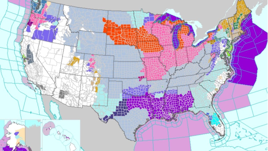
Winter storm and blizzard warnings were issued for millions of Americans on Thursday as a winter storm brought harsh conditions and heavy snow across the Midwest and Plains regions.
An updated map posted by the National Weather Service (NWS) shows winter storm and blizzard warnings were issued from eastern Montana to parts of Michigan and western New York due to the storm.
“An Arctic blast of dangerous and life-threatening cold will consume much of the Lower 48 over the next few days. Wind chill warnings, watches and advisories currently extend from the Northwest to as far south as the Gulf Coast and east into the Eastern U.S.,” said the NWS on Thursday morning as of 11 a.m. ET. “A powerful winter storm is also expected with the blast to produce heavy snow and blizzard conditions in the Midwest and Great Lakes.”
Describing the system as “major” and “anomalous,” the NWS further warned that it will produce “widespread disruptive and potentially crippling impacts” across the country. By Thursday, thousands of flights were canceled or delayed across major U.S. airports, according to Flightaware.com, a tracking service, coming as millions of Americans are either set to travel for the Christmas break.
“At the forefront of the impressive weather pattern is a dangerous and record-breaking cold air mass in the wake of a strong arctic cold front diving southward across the southern Plains today and eastward into the Ohio/Tennessee Valleys by tonight,” the bulletin stated. “Behind the front, temperatures across the central High Plains have already plummeted 50 degrees F in just a few hours, with widespread subzero readings extending throughout much of the central/northern Plains and northern Rockies/Great Basin.”
Leading into the holiday weekend, the system is expected to bring blizzard conditions to the Great Lakes region, up to 2 inches of rain followed by a flash freeze on the East Coast, wind gusts of 60 mph and bitter cold as far south as the Mexican border.
More Details
As the storm moves over the Great Lakes, a weather phenomenon known as a bomb cyclone is expected to develop due to “the abrupt deepening of this low pressure system,” the National Weather Service said. In its wake, the cyclone could spawn snowfalls of a half inch an hour and winds of more than 50 mph in the Upper Midwest and interior Northeast, the weather service said.
How much did the temperature change in an hour or less as the cold front passed? Here is a graphical depiction using the real-time mesoscale analysis grids. The grid showed max drop was near -47 degrees in NE Colorado. Included is the actual record drop trace at Cheyenne, WY. pic.twitter.com/ct47GE2ppo
— NWS Weather Prediction Center (@NWSWPC) December 22, 2022
Georgia on Wednesday joined North Carolina and Kentucky in declaring states of emergency. Temperatures in north Georgia were forecast to hit 10 degrees F with subzero wind chills.
More than half of the Lower 48 states, from Washington state to Florida, are under winter weather alerts, including wind chill advisories affecting about 135 million people, said Ashton Robinson Cook, a meteorologist at the weather service’s Weather Prediction Center.
“Wind chills of this magnitude can cause frostbite in less than 5 minutes if precautions are not taken, with hypothermia and death also possible from prolonged exposure to the cold. Livestock interests will also be severely impacted and dangers could be exacerbated if power outages occur,” the NWS also stated. “Consequently, widespread Wind Chill Warnings, Watches, and Advisories span across over 30 states from Washington to Florida. Daytime temperatures across the central Plains will struggle to get above 0 degrees, while areas further south in Texas and the Gulf Coast will experience temperatures in the single digits and teens Thursday evening.”
U.S. power and natural gas prices in the Midwest and West Coast soared to multiyear highs on Thursday. Gas output was on track to drop about 4.7 billion cubic feet per day (BCFD) over the past three days to a preliminary seven-month low of 94.3 BCFD on Thursday due to frozen wells in Texas, Oklahoma, North Dakota, Pennsylvania, and elsewhere.
That would be the biggest daily drop in output since the freeze of February 2021 when a winter storm cut gas supplies from Texas and forced the Texas electric grid operator to impose rolling power outages. One billion cubic feet is enough gas to supply about 5 million U.S. homes for a day.
Reuters contributed to this report.
From The Epoch Times

