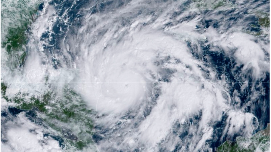
Hurricane Eta quickly intensified into a major storm on Monday and is forecasted to continue strengthening before making landfall in Central America early on Tuesday with devastating winds and rain.
Eta had maximum sustained winds of 120 mph as of 1 p.m. ET and was located about 85 miles east of the Nicaragua-Honduras border, according to the National Hurricane Center.
The slow-moving storm is going west toward the coast of Central America at 9 mph and is forecasted to continue strengthening until it reaches the coast of Nicaragua, the NHC said.
The major hurricane is expected to reach wind strengths between 130 and 156 mph, at which time it will reach category 4 status on the five-step Saffir-Simpson scale.
#Eta has rapidly intensified to a major hurricane with maximum sustained winds of 120 mph. Continued strengthening is expected before it makes landfall along the northeastern coast of #Nicaragua on Tuesday.https://t.co/a6nU87U3bG pic.twitter.com/yFRb0ObYHt
— National Hurricane Center (@NHC_Atlantic) November 2, 2020
The storm’s center is expected to move into northern Nicaragua early on Tuesday through early Wednesday at a slow-moving pace that could result in catastrophic wind and rain damage. The outer bounds of the storm are forecast to drop rainfall close to the prodigious amounts of water dumped by 1998’s Hurricane Mitch, one of the deadliest Atlantic storms in history.
The NHS said Eta will decrease in strength after the system starts moving inland.
Forecasters said central and northern Nicaragua into much of Honduras could get 15 to 25 inches of rain, with 35 inches in isolated areas. Heavy rains also were likely in eastern Guatemala, southern Belize, and Jamaica.
“This rainfall would lead to catastrophic, life-threatening flash flooding and river flooding, along with landslides in areas of higher terrain of Central America,” according to an NHC advisory. “Flash flooding and river flooding would be possible across Jamaica, southeast Mexico, El Salvador, southern Haiti, and the Cayman Islands.”
Hurricane warnings are activated for the entire Nicaragua coast and a tropical storm warning is in effect for the northeastern coast of Honduras. In Honduras, much of the country was placed on red alert for Eta’s eventual passage through the country. It had been raining since Sunday in some areas.
TROPICAL UPDATE: Here’s the latest visible/infrared “sandwich” loop of #HurricaneEta from @NOAA‘s #GOES16????️ this morning. A small eye has recently become apparent on satellite, and #Eta is expected to rapidly strengthen to a Cat-3 #hurricane today. More: https://t.co/VTAp4gGkHs https://t.co/stOoMhhMuV pic.twitter.com/8A2klpEACO
— NOAA Satellites – Public Affairs (@NOAASatellitePA) November 2, 2020
“A dangerous storm surge will raise water levels by as much as 12 to 18 feet above normal tide levels in areas of onshore winds along the coast of Nicaragua within the hurricane warning area, and 3 to 5 feet above normal tide levels along the coast of Honduras within the tropical storm warning area. Near the coast, the surge will be accompanied by large and destructive waves,” the advisory said.
“Swells generated by Eta are expected to affect portions of the coast of Central America and the Yucatan Peninsula of Mexico during the next few days. These swells are likely to cause life-threatening surf and rip current conditions,” it continued.
Eta is the eighth Atlantic storm this season to hit the meteorologists’ definition for rapid intensification—a gain of 35 mph in wind speed in just 24 hours. It’s also the fifth to reach major hurricane status.
Hurricane season still has a month to go, ending Nov. 30.
The Associated Press contributed to this report.


