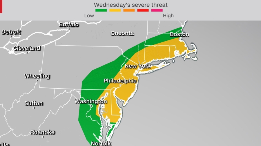
The rain-drenched Northeast has another threat for severe weather on Wednesday, including New York City and Boston, as a cold front pushes eastward from the Great Lakes.
The Storm Prediction Center (SPC) warns of a slight risk (level 2 of 5) Wednesday of severe weather for coastal portions of the Northeast.
“Scattered strong to severe thunderstorms are possible Wednesday afternoon from New Jersey northward through southern New England. Hail and damaging winds are expected to be the primary threats,” said the SPC.
Some spotty showers and clouds are moving through western parts of the region Wednesday morning, left behind from a round of storms Tuesday evening.
Although skies are clear of clouds and rain in most cities along the coast, thick wildfire smoke from large Western fires has settled into the area, giving the sky a thick orange and red hue at sunrise.
The fires are showing explosive activity and hurling smoke into the air so high that it is being trapped in upper atmospheric air masses and carried across the country, where in some locations it is able to make its way to the ground.
Images of New York City shrouded in a veil of smoke from the fires thousands of miles away show the smoke mixed down to the surface, creating an eerie scene Wednesday morning.
The strong cold front moving through Wednesday night is expected to clear out the skies behind it as the front ushers the surface level smoke out of the region.
Midday, mostly clear skies along the coastal areas could provide the energy needed from daytime heating to ignite strong to severe storms in the afternoon and evening.
“The timing of the convection will be a key in determining if severe weather can materialize across the region,” said the National Weather Service in New York City.
If cloud cover from Wednesday morning showers remains through midday, the severe threat could be stifled.
The cold front pressing east from the Great Lakes will begin to spark showers in western New England before it makes its way further toward the coast, interacting with marine moisture that will help fuel storms.
Supercell thunderstorms capable of producing large hail and damaging wind gusts will be possible as storms track towards the east through the afternoon.
Cities including New York, Boston and Philadelphia have the greatest chance of seeing severe storms move through this evening.
Unrelenting Rain
Rain is seemingly unrelenting in the region from weeks of rainfall already greatly surpassing monthly averages.
Central Park in New York City has already collected 9.15 inches of rain this month, 6.45 inches more than normal. This makes it the fourth wettest July on record, according to the NWS.
Up to 2 inches of rainfall is possible, especially near the coast in the Northeast and up through New England. The highest totals will be localized heavy downpours where the strongest storms pass over.
“Locally heavy rainfall should be brief, but isolated flash flooding cannot be ruled out due to moist soils,” said NWS Albany.
The moist soils in the region could cause flooding concerns, as well as in the metro areas. The Weather Prediction Center has issued a marginal risk of excessive rainfall up the northeast coast from Delaware to Maine due to the potential for flooding.
After the cold front makes its way off the Atlantic coast Wednesday night, temperatures behind the front will be milder and more seasonal, with dry air replacing the humid and hot conditions that have taken charge this week.
By Hannah Gard and Monica Garrett


