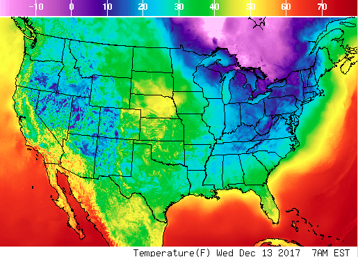
Temperatures are expected to dip across the Midwest and parts of the Northeast bringing snowfall and chilly winds into early next week.
According to The Weather Channel, a series of snowmakers are expected to bring several inches of snow from the Great Lakes region to the Northeast on Wednesday until Thursday morning.

A rapidly moving low pressure system—known as a clipper system—will dump moderate to heavy snow across parts of Minnesota and Wisconsin on Wednesday, Dec. 13, then head southeastward across the Great Lakes and into western Pennsylvania by late afternoon or early evening, reported the weather site.
The area, which will see the heaviest snow is Lower Michigan, including Detroit. The total accumulation of up to 6 inches of snow is expected during the evening.
In Cleveland and Pittsburg, snow is expected to fall in the afternoon and also affect the evening commute, reported The Weather Channel.

On Wednesday night, lighter amounts of snow are forecasted across Pennsylvania and into parts of New Jersey, the Delmarva Peninsula, and western and central New York, as well as into the mountains of West Virginia.

Along with the snow, chilling winds may also affect these areas, causing blowing and drifting of any snow that falls, according to the National Weather Service (NWS).
The NWS warns that the system will likely lead to slick and snow-covered roadways as well as reduced visibility, and possibly cause travel disruptions for evening commuters.

By Thursday, the clipper system is expected to peter out and dissipate, reported The Weather Channel.
Another clipper system will spread light snow across the upper Midwest and Great Lakes on Friday, Dec. 15, and then move east on Friday night and into Saturday, Dec. 16.
From Sunday night to Monday night, a third system will bring further light snow to northern areas such as upstate New York and northern New England. The Interstate 95 corridor from Boston southward is expected to see rain or a rain/snow mix, reported the weather website.
Dear reader,
We have a little favor to ask of you. We work hard to deliver important and interesting articles to you. Please help support independent journalism by sharing this article with your friends and family. It takes less than a minute. Thank you!

