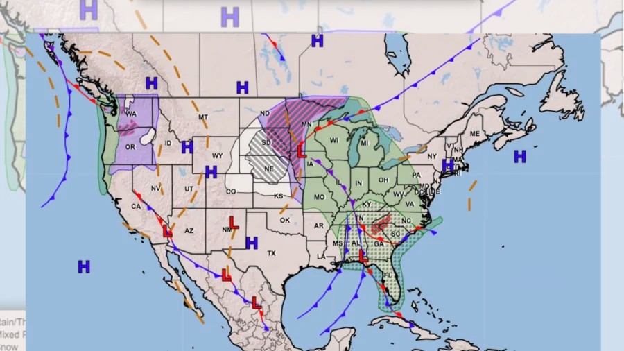
A “significant” winter storm is set to bring heavy snow to many in the Plains and create “hazardous” travel conditions, while much of the country can expect a wet, rainy Christmas, the National Weather Service said.
In an update posted on Monday, the National Weather Service’s Weather Prediction Center said that the storm will “let it snow, let it snow, let it snow” over portions of the Central Plains where blizzards potentially make holiday travel dangerous.
This large, intensifying storm system will bring “multifaceted impacts” to the central and eastern United States this Christmas, the Center noted.
The Central Plains and Upper Midwest are expected to see heavy snow and ice, forecasters said. On the western flank of the storm, heavy snow will increase in coverage and intensity throughout Christmas Day across northern Kansas, Nebraska, and South Dakota. The snowfall will likely reach at least 4 inches, and there is a strong possibility (greater than 70 percent) for the snow to accumulate more than a foot across the region from central Nebraska to south-central South Dakota.
In addition, very strong winds with gusts upwards of 55 mph could lead to blizzard conditions.
“While a White Christmas may be exciting for those nestled at home, the heavy snowfall rates and reduced visibilities due to blowing snow will make for hazardous to even impossible travel conditions,” the Center advised.
According to predictions, icing is expected across the region from the Red River Valley to northern Minnesota, with moderate chances (40 to 60 percent) for ice greater than a quarter of an inch to exist in southeast North Dakota. Local residents are told to be prepared for treacherous travel conditions, slippery sidewalks, and isolated power outages.
By Tuesday, the storm will gradually weaken, but still produce heavy and blowing snow as it shifts more westward into the central High Plains.
In the eastern part of the country, moisture from the Gulf of Mexico funneling north ahead of a passing cold front will spawn numerous showers and a few thunderstorms, the weather center said. This will bring moderate to heavy rainfall in the region from the Great Lakes to the Ohio Valley and the Southeast.
Parts of the Southern Appalachians are expected to experience very heavy rainfall of several inches, and some instances of flash flooding will be possible.
In terms of temperature, the Center noted that multiple record minimum and maximum warm temperatures were reached on Christmas Eve. It anticipated “more unusually mild” temperatures on Christmas Day in the Upper Midwest and Great Lakes, where highs in the 50s are running between 15 to 25 degrees above normal.
“Temperature-wise, it will not be feeling a lot like Christmas from the Upper Mississippi Valley on east to the Great Lakes and East Coast,” Monday’s update read.
“The East Coast will not witness quite the anomalous warmth that the Midwest and Great Lakes will, but daily average temps will still be rather mild and could range between 10-15 degrees above normal in parts of the Northeast,” it added. “Tuesday continues to be exceptionally mild in the Great Lakes and along the East Coast with more record breaking warm min temperatures scattered throughout the Great Lakes.”
In contrast, the central-southern Plains and central-southern Rockies will be the coolest versus normal thanks to a recent cold frontal passage injecting the region with an air mass that “feels a lot more like Christmas,” with 30s and 40s to the north and 50s to the south, according to the Center.
For the West, conditions will be around average, with 30s and 40s for the Great Basin, 50s and 60s along the coast, and 60s and 70s into the Desert Southwest.
From The Epoch Times

