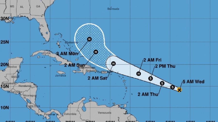
Three tropical storms Jerry, Lorena, and Mario are expected to become hurricanes this week.
Tropical Storm Jerry has become the 10th named storm of the Atlantic Hurricane Season. It’s still far from land, but it’s gaining intensity and forward speed on a path to approach the Leeward Islands.
Tropical Storm #Jerry Advisory 4: Jerry Becomes the Tenth Named Storm of the 2019 Season. https://t.co/VqHn0uj6EM
— National Hurricane Center (@NHC_Atlantic) September 18, 2019
The storm is forecast to become a hurricane as it nears the outermost Caribbean islands Thursday night or Friday. But it’s too soon to tell if the islands will be impacted, the hurricane center said.
The storm is moving west-northwest at 13 mph and could also impact the Lesser Antilles by early Saturday morning, CNN meteorologist Michael Guy said.
Tropical Storm #Jerry Advisory 5: Jerry Strengthening Over the Tropical Atlantic Ocean. https://t.co/VqHn0u1vgc
— National Hurricane Center (@NHC_Atlantic) September 18, 2019
Tropical Storm Lorena is a little stronger, and Mario is strengthening as well. Both Lorena and Mario are expected to become hurricanes by Friday as they approach the Mexican coast.
Forecasters warned heavy rains and flooding to resorts from Zihuatanejo to Cabo Corrientes. Lorena had top winds of 60 mph (95 kph) early Wednesday and was centered about 145 miles (230 kilometers) southwest of Zihuatanejo, moving northwest at 14 mph (22 kph).
Here are the Latest Key Messages for Tropical Storm Lorena as it approaches the Mexican Coast (4 AM CDT Wednesday, September 18) More info: https://t.co/sYVOB3gkmI pic.twitter.com/K4e0m85uW4
— National Hurricane Center (@NHC_Atlantic) September 18, 2019
Further off Mexico’s Pacific Coast, Tropical Storm Mario is also expected to become a hurricane by Friday as it approaches the southern tip of Baja California and become nearly stationary through Friday night.
Other storms are roiling the Pacific Ocean off the coast of Mexico. Kiko has stopped weakening but is headed away from land.
Tropical Storm Imelda Makes Landfall
Tropical Storm Imelda made landfall in Texas on Tuesday and it could give the Houston area its heaviest rainfall from one storm since Hurricane Harvey, raising prospects of heavy flooding in a city that sees plenty of it.
Rescue teams in southeast Texas are getting ready for Imelda, which is forecast to bring flooding to the area even after weakening to a tropical depression.
The storm, which early Wednesday was centered about 25 miles north-northwest of Houston, is expected to drop 6 to 12 inches of rain in the next two to three days across portions of eastern Texas, the National Weather Service’s Weather Prediction Center said. As much as 18 inches could fall in isolated spots.
Imelda is slowly moving inland and has the potential to be among the more destructive storms in the U.S. in recent months because of the amount of rainfall, CNN meteorologist Pedram Javaheri said.
Red flag warnings have gone up along the coast of Galveston, Texas. And the federal search and rescue team Texas A&M Task Force 1 has moved into the city in preparation for possible rescues, according to CNN affiliate KTRK.
“Our forte is water rescue, both flood rescue and swift water rescue,” Palmer Buck, with Task Force 1, told the station. “I have crews from Fort Worth fire, as well as Longview fire that will be stationed here overnight.”
A National Guard team is expected to arrive Wednesday, as well, KTRK reported.
In Houston, flash flood conditions could continue through Friday and residents should stay indoors, Fire Chief Samuel Peña told KTRK.

After drenching coastal Texas and southwestern Louisiana through Wednesday, the storm system is expected to douse eastern Texas and western Louisiana on Thursday, the hurricane center said.
As much as 9 inches of rain had fallen by Wednesday morning in some areas southeast of Houston, according to the Harris County Flood Warning System. Most parts of Houston saw 2 to 4 inches of rain.
Hurricane Humberto
The year’s second major Atlantic hurricane is expected to deliver strong winds and large swells to Bermuda as it makes a rare pass Wednesday night just north of the Atlantic island territory.
People on Bermuda rushed to make final preparations for an expected close brush with Hurricane Humberto, a powerful Category 3 storm that caused authorities on the British Atlantic island to order early closings of schools, transportation and government offices.
National Security Minister Wayne Caines said schools, government offices and ferries on the island would close at noon and bus service would halt at 4 p.m.
Officials expected tropical-storm-force winds to begin whipping at Bermuda before dawn and warned that hurricane-force gusts would probably last until early Thursday. Humberto was predicted to pass just to the north, though a small shift in its path could bring the storm over the island itself.
The U.S. National Hurricane Center said Humberto’s maximum sustained winds strengthened to 115 mph (185 kph) and it would probably remain a Category 3 hurricane through Thursday though there could be some fluctuations in its winds. The storm was centered about 285 miles (458 kilometers) west of Bermuda early Wednesday, moving east-northeast at 16 mph (256 kph).
Here are the Latest Key Messages for Hurricane #Humberto as it approaches Bermuda (4 AM CDT Wednesday, September 18) More info: https://t.co/sYVOB3gkmI pic.twitter.com/CUjSTFZp3Z
— National Hurricane Center (@NHC_Atlantic) September 18, 2019
“It is large enough in nature here to where we will have some of those outer bands impact the island (of Bermuda) and also see some hurricane-force gusts associated with this,” CNN meteorologist Pedram Javaheri said early Wednesday.
Hurricane-force winds of at least 74 mph extend 60 miles from Humberto’s core, with tropical storm force winds of 39 mph or stronger reaching 175 miles from the storm’s center, CNN meteorologist Judson Jones said.
“They’ll get tropical-storm-force winds, for sure,” Jones said of Bermuda. Two to 4 inches of rain, dangerous waves along south-facing beaches and a storm surge of 1 to 3 feet also are expected, the hurricane center said.
The CNN Wire and The Associated Press contributed to this report.

