LAFD Issues Evacuation Orders as Powerful Storm Threatens Floods, Mudslides in Burn Areas

Published: 3/12/2025, 11:54:54 PM EDT
LAFD Issues Evacuation Orders as Powerful Storm Threatens Floods, Mudslides in Burn Areas
An overhead pole camera image shows wildfire damage at the Altadena Community Church destroyed by the Eaton Fire in Altadena, Calif., on Jan. 14, 2025. (Patrick T. Fallon/AFP via Getty Images)

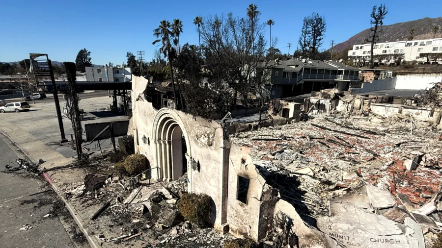
The Los Angeles Fire Department (LAFD) issued evacuation orders Wednesday morning for several neighborhoods ahead of a winter storm forecasted to hit the region, bringing heavy rains that threaten to trigger flooding, mudslides, and debris flows, including in areas recently devastated by recent fires.

According to a Tuesday news release from the LAFD, the evacuation warnings are in effect from 7 a.m. Wednesday to 6 p.m. Thursday as the storm passes through.

The warnings include neighborhoods impacted by the Palisades Fire, including the Getty Villa vicinity, Highlands near burn zones, Bienveneda near Temescal Canyon Park, Rivas Canyon and Will Rogers State Park area, Mandeville Canyon above Tanners Road, and Old Ranch Road and Rustic Creek.

Residents were advised to begin their preparations immediately before heavy rains began.

The National Weather Service (NWS) labeled the storm as moderate to strong in a Wednesday forecast, calling for periods of moderate to heavy rain and mountain snow across Southwest California from Wednesday afternoon through Thursday morning.

According to the NWS's Area Forecast Discussion, traveling during the storm could become dangerous due to the potential for flooding and mudslides near recent burn scars.

The forecast predicts the strongest portion of the storm to move into Southern California overnight Wednesday into early Thursday morning. The NWS said despite the storm's rapid movement through the area, heavy rainfall is predicted to exceed the threshold needed to produce debris flows, with a 60 to 80 percent likelihood that hourly or sub-hourly rainfall rates will surpass such thresholds in the foothill and mountain regions.

The weather service has also warned that isolated thunderstorms may develop Thursday, potentially bringing light hail and snow as low as 2,500 feet. Travel disruptions are expected along major routes such as Interstate 5 near Tejon Pass and Highway 14 near Acton and 33 north of Ojai. The NWS also noted isolated downed trees and power outages are possible due to strong winds.

The forecasted storm follows on the heels of an earlier one in February which caused damage in communities affected by wildfires. Residents near the Eaton Fire burn scar were met with mudslides after heavy rains submerged roads and damaged homes in Sierra Madre, with similar damage occurring in Pacific Palisades following that storm.
The LAFD recommends residents facing major storms keep a go bag ready with essential documents, phone numbers, and medications. People are also encouraged to turn off yard sprinklers, lower the level of water in their swimming pools, and inspect their homes, gutters, windows, attic, and other places to prevent any leaks or flooding. Sandbags are recommended to soak up the water around homes, with ready-to-fill sandbags available at all neighborhood fire stations, which can be found on this interactive map.