

The amount of rain is likely to lead to life-threatening flash floods and landslides, as well as a storm surge that will raise water levels by as much as 2 to 4 feet above normal tides along the coast, according to the NHC.
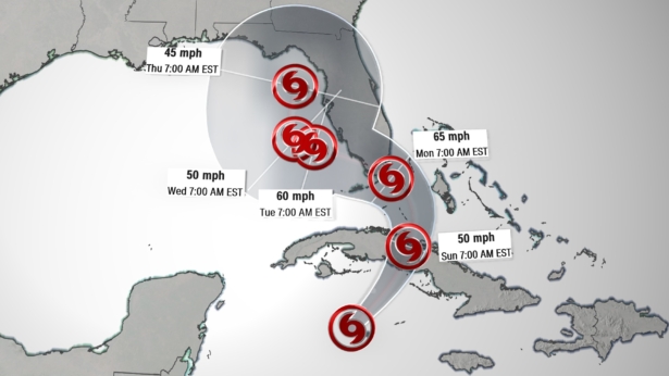
The storm is forecast to cross through Cuba and become a hurricane by Monday morning and head toward southern Florida and the Keys. A hurricane warning has been issued for the Florida Keys from Ocean Reef to the Dry Tortugas, including Florida Bay.
At least five school districts in south Florida, including Miami-Dade, will close on Monday due to Eta's potential impact, the districts announced on social media.
In Miami-Dade, all bridges have been locked down, Mayor Carlos Gimenez said. He said to expect 40 to 60 mph winds beginning Sunday at 4 p.m. through Monday at 2 p.m., as well as the possibility of tornadoes.
By late Monday and into Tuesday, Eta will move into the Gulf of Mexico, the NHC said.
A tropical storm warning also is in effect for the Cayman Islands, portions of central Cuba and the northwestern Bahamas.
Latin America and Caribbean Prepare for Damage
In Latin America and the Caribbean, emergency disaster plans are currently in place in Cuba and Mexico while evacuation and relief efforts continue in Guatemala and Honduras, which have been the hardest hit so far, with dozens dead or missing.In Cuba, the country's Civil Defense updated its warnings on Saturday and issued an "Alarm Phase" for several western and central areas.
"In the face of Eta, there is no time to waste and protection is the priority," Cuban President Miguel Díaz-Canel tweeted on Saturday.
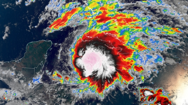
In Mexico, the National Meteorological Service said Eta's "broad circulation is causing intense to torrential rains on the Yucatan peninsula and in southeastern Mexico." The rain is expected to last through Monday, the service said, and will affect the states of Chiapas, Oaxaca, Quintana Roo, Tabasco and Yucatán.
Lopez Obrador warned of a potential "emergency situation" in Tabasco as widespread flooding from Eta is expected, and said he is calling an emergency meeting of the Security Cabinet.
"We are talking about rainfall never seen before" in the area, López Obrador said in a video message posted on his official Twitter account.
Eta Eyes Southern Florida
Florida Gov. Ron DeSantis declared a state of emergency for eight counties on Saturday as Eta approaches, according to Fredrick Piccolo Jr., communications director for the governor.The governor declared the emergency for Broward, Collier, Hendry, Lee, Martin, Miami-Dade, Monroe and Palm Beach counties in south Florida "out of an abundance of caution," Piccolo said. The counties include the cities of Miami, West Palm Beach, Fort Lauderdale, Fort Myers and Key West.
The hurricane watch covers the coast of southern Florida from Deerfield Beach to Bonita Beach. A hurricane watch means hurricane conditions are possible within the next 48 hours.
A tropical storm warning is in effect for the Florida coast from Brevard/Volusia County line to Englewood, including Florida Bay, as well as Lake Okeechobee.
"Recent heavy rain across the region has led to saturated ground and urban flash flooding could become a threat by the end of the weekend and into early next week depending on the forward movement of the storm," CNN meteorologist Derek Van Dam said.
A flood watch is in effect for much of southern Florida through Tuesday evening.
Mayor Gimenez declared a state of emergency Friday as Miami-Dade monitors the storm. Gimenez said the ground is already saturated from days of rainy conditions so "flooding is a major concern."
Besides heavy rain, Eta is expected to bring dangerous storm surge to coastal areas of Florida. A storm surge of 2 to 3 feet is forecast from North Miami Beach to Marco Island, including Biscayne Bay and the Keys. A storm surge of 1 to 2 feet is forecast for portions of Florida's east coast from the Flagler/Volusia County line to North Miami Beach.
After Eta passes southern Florida and the Keys, there is still uncertainty as to where the storm will track next in the Gulf of Mexico. There are a handful of mid- and upper-level atmospheric steering patterns responsible for Eta's seemingly erratic forecast track. Due to all of this steering, changes in the track or forward motion of Eta are likely over the weekend.