
The 7.1 magnitude earthquake that shook California on July 5 also ripped open a fissure.
The immediate damage it caused was very clear. Stores had broken bottles and exploded cans littering their floors and other items that had been hanging on walls had toppled over.
As the sun rose the next day, it also became clear that the area's topography had changed.
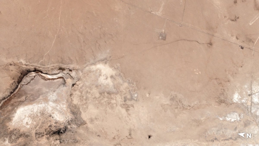
Satellite images provided to CNN by Planet Labs, Inc. show a crack has formed in the area close to the epicenter.
The large crack extends some distance from an area that apparently held water before. The erosion patterns on the desert sand indicate that some of that water was sucked out.
The satellite image isn't the only evidence that the region's topography was changed by the earthquake.
The Big One Is Coming
According to geologists, a major earthquake along the San Andreas Fault is likely "overdue."A major 7.9-magnitude quake in San Francisco in 1906 means there's a slightly lower chance of a major earthquake happening in the northern part of the state, the USGS website said.
Many residents, like Steve Rios of Riverside, California, are acutely aware of the threat.
"I would honestly say it's something Californians are always cognizant of because of the San Andreas Fault being here," he said.
"We're standing on two different (sides) of the fault line," he pointed out. "It's kind of a scary feeling."
Last week's tremors probably won't increase the likelihood of a major earthquake on the San Andreas Fault, seismologists said. They occurred near Ridgecrest, north of the fault.
But they also don't make it less likely, Dr. Lucy Jones, a seismologist with the California Institute of Technology, told reporters Thursday.
There's about a 2% chance of the Big One occurring each year, Jones said on Twitter this week, or about 1 in 20,000 every day. While the chances may not be high, residents shouldn't be caught unaware.
"One should always be preparing for a Big One," she said.
But going forward, "this is more what we should be thinking about," she said.