
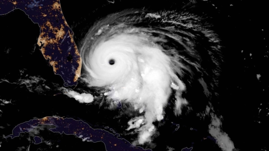
Dorian is scraping the central part of Florida’s east coast as it tracks offshore.
The U.S. National Hurricane Center says Dorian is now about 110 miles east of Cape Canaveral, Florida. Maximum sustained winds are being clocked at 110 mph. It’s moving to the northwest at 6 mph.
Dorian virtually stalled over the northwestern Bahamas in recent days as a Category 5 storm that caused widespread devastation in parts of the island archipelago. It was the most powerful hurricane on record ever to hit the Bahamas. At least five deaths were reported there though the full scope of the disaster still remains unknown.
The prime minister of the Bahamas says the death toll from Dorian has risen to seven and that more deaths are expected.
Hubert Minnis says the deaths involved two people who were injured earlier and taken to New Providence Island. He spoke late Tuesday at a news conference.
More than a quarter-million visitors and residents have been told to leave North Carolina’s coastal region ahead of Hurricane Dorian.
The most populous coastal county to be evacuated is Dare County, where 250,000 people, including 36,000 residents, have been told to get out.
In New Hanover County, where flooding cut off the city of Wilmington during last year’s Hurricane Florence, officials said they didn’t expect a similar issue from Dorian. They say the storm isn’t expected to dump as much rain and the ground isn’t as saturated as it was last year.
The U.S. National Hurricane Center adjusted its forecast tracks on Tuesday putting Dorian closer to the South and North Carolina coasts. Forecasters noted that even if Dorian doesn’t make landfall, it’s likely to bring dangerous winds, life-threatening storm surge and flooding rains to parts of the Carolinas.
It said the core of Dorian will move close to the east coast of Florida before tracking north along the coast of Georgia.
Then, according to NHC forecasters, the “center of Dorian is forecast to move near or over the coast of South Carolina and North Carolina Thursday through Friday morning.”
Winds are increasing along parts of Florida’s East Coast as Hurricane Dorian tracks offshore in the Atlantic.
The U.S. National Hurricane Center says the Category 2 storm was centered at about 5 p.m. ET Tuesday about 105 miles east of Vero Beach, Florida. Top sustained winds are at 110 mph and Dorian is moving to the northwest at 6 mph.
Forecasters say Dorian is expected to move dangerously close to the coast of Florida and Georgia from Tuesday night through Wednesday night before menacing the coast of the Carolinas Thursday and Friday.
The hurricane center has adjusted its forecast tracks closer to the coasts of South and North Carolina, noting “a track that close to the coast, even if landfall does not occur, is likely to bring dangerous winds, life-threatening storm surge, and flooding rains across the eastern portions of the Carolinas.”
The core of Hurricane Dorian continues to move away from Grand Bahama island. However, the U.S. National Hurricane Center (NHC) warns dangerous winds and life-threatening storm surge will continue over the island through Tuesday evening.
Tropical storm force winds are now occurring along Florida's east coast, according to the 3 p.m. update from the NHC.
A sustained wind of 39 mph and a wind gust of 49 mph were recently reported at a weather station in Sebastian Inlet, Florida.
The center of Hurricane Dorian is finally moving away from Grand Bahama island but the U.S. National Hurricane Center says the island will continue getting dangerous winds and life-threatening storm surge through the evening.
Dorian’s maximum sustained winds Tuesday afternoon remain at 110 mph, making it a Category 2 hurricane.
The hurricane is centered about 65 miles north of Freeport and is moving northwest near 5 mph.
Practically parking over the Bahamas for a day and a half, Dorian has been pounding the islands in a watery onslaught that devastated thousands of homes, trapped people in attics and crippled hospitals.
Meanwhile, Tropical Storm Fernand has formed in the Gulf of Mexico, prompting a tropical storm warning for Mexico’s northeast coast.
As Hurricane Dorian pounds the Bahamas, a new tropical storm has formed in the Gulf of Mexico.
Tropical Storm Fernand formed Tuesday afternoon, prompting a tropical storm warning for Mexico’s northeast coast.
The storm’s maximum sustained winds are near 40 mph. The U.S. National Hurricane Center says slow strengthening is expected before the storm moves inland. It’s centered about 160 miles east of La Pesca, Mexico, and is moving west near 7 mph.
Hurricane Dorian grew in size and picked up speed on Tuesday, and was forecast to come "dangerously close" to Florida's coast after pounding Grand Bahama Island for about a day, killing at least five people.
The hurricane weakened early on Tuesday to a Category 2 on the five-step Saffir-Simpson Wind Scale, with maximum sustained winds of 110 miles per hour, the National Hurricane Center (NHC) said. It was moving northwest at 2 mph, below walking speed, and was about 105 miles east of Fort Pierce, Florida.
The NHC warned that Dorian remained dangerous despite the reduced wind speed.
"The headline for this #Dorian advisory is NOT that the wind speed has slightly decreased," it said on Twitter. "The combined wind, surge, and floods hazards are the same or even worse since the hurricane has become larger."
Officials in northeastern Florida are urging people to stay away from the beaches due to possible storm surge from Dorian .
Flagler County Emergency Management Director Jonathan Lord said Tuesday that waves of up to 20 feet (6 meters) are expected along the area’s Atlantic beaches as the storm moves toward the north.
He says there can still be “life-threatening if not deadly conditions at the beach.”
Lord said storm surge is expected along the ocean and the Intracoastal Waterway.
Hurricane Dorian remains stalled over the Bahamas, according to the latest official forecast, but is expected to start tracking north-northwest later this morning.
That designation means winds have dropped to speeds of 120 mph from the 185 mph sustained speeds that battered the Caribbean islands as it made landfall as a Category 5 storm.
"Dorian is stationary just north of Grand Bahama Island," said the NHC update. "A slow north-northwestward motion is expected to begin this morning. A turn to the north is forecast by Wednesday evening, followed by a turn to the north-northeast Thursday morning."