
The first super typhoon of the season in the West Pacific is closely approaching the Central Philippines this weekend.
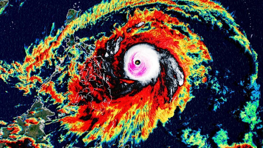
On Saturday afternoon local time, the typhoon strengthened into a super typhoon with sustained winds of 150 mph (240 kph). By Saturday night the super typhoon had intensified even further to 180 mph (287 kph), which is equivalent to a strong category 5 Atlantic hurricane.
Surigae is now the strongest typhoon on record for the month of April, surpassing Typhoon Thelma in 1956 which had maximum sustained winds of 278 kph (173 mph), according to the National Oceanic and Atmospheric Administration historical hurricane database.
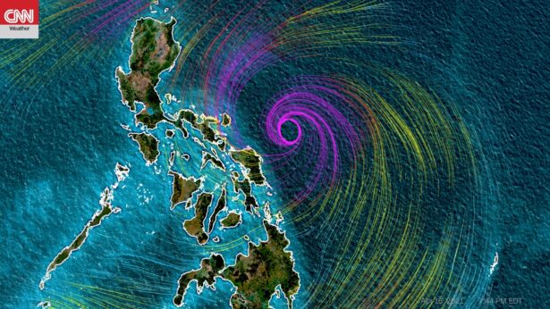
The current track has Surigae maintaining this strength for the next couple hours prior to weakening while passing just off of the east coast of the Philippines. The outer bands of the super typhoon continue to impact the Philippines. The storm will make its closest approach to the region on Sunday local time bringing with it tropical storm-force winds, heavy rain, and rough seas.
Super Typhoon Surigae has been slowly moving toward the Philippines since it developed earlier this week, yet rapidly intensified on Friday, and then again on Saturday. Rapid intensification occurs when a tropical cyclone strengthens 35 mph in a 24 hour period.
This rapid intensification happened due to the ideal conditions for typhoon development: Wind shear, or the changing of wind speed and direction with height in the atmosphere, has been very low. High wind shear can tear storms like this to pieces, but low shear allows them to feed off the extremely warm waters and flourish into a powerful storm.
Forecast Shifts Closer to the Philippines
Earlier in the week, the projections for Surigae were to track to the west toward the Philippines before turning to the northwest and north, comfortably missing the Philippines to the east. However, over the past few days several weather forecast models showed a trend for the storm to track closer to the Central Philippines.While most forecast models, as well as official forecasts from the Joint Typhoon Warning Center and the local authorities with the Philippine Atmospheric, Geophysical and Astronomical Services Administration (PAGASA), show the center of Typhoon Surigae passing approximately 100 miles offshore of the Philippines on Saturday night and Sunday, the storm will pass close enough to bring significant impacts.
On this current trajectory, the strongest winds of over 100 mph (160 kph) and the worst of the rainfall would remain offshore, but the storm would pass close enough to bring tropical storm-force winds (39-73 mph, 63-117 kph) and four to eight inches (100-200 mm) of rain.
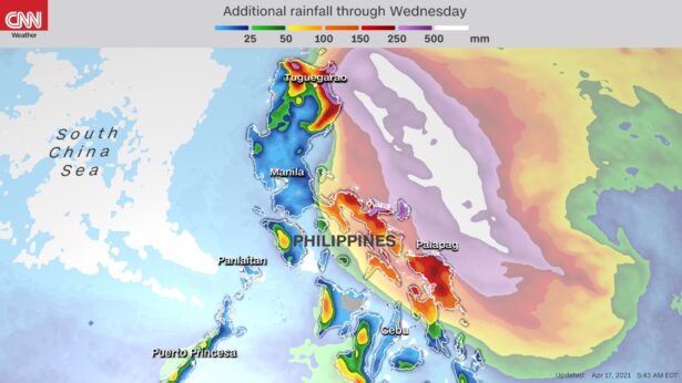
This rain and wind could be enough to cause localized flooding, minor property damage and power outages. PAGASA has already issued warnings as conditions are expected to deteriorate Sunday morning local time. If the westward trend continues, the impact will worsen and additional warnings will be issued.
Regardless of the exact track, a storm of this magnitude will generate giant surf and mariners in the region have been advised to use caution.
Even if Surigae remains offshore this weekend, it will need to be monitored into next week as it slowly moves to the northwest and north.