
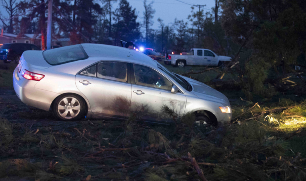
The Southern severe weather streak continues on April 23 with yet another round of extreme weather possible a day after storms killed at least six people in Texas, Oklahoma and Louisiana.
Hundreds of tornadoes have been reported across the eastern half of the U.S. in April, most occurring across the Deep South.
On Wednesday evening, a tornado that touched down in southern Oklahoma killed two people and injured a number of others, according to officials.
Several vehicles were thrown into trees and there was damage to two steel manufacturing companies, Robert Chaney, director of Marshall County Emergency Management, said.
In Polk County, Texas, a tornado produced by a strong supercell thunderstorm killed three people and injured 20 to 30 others, according to county officials. A disaster declaration issued after the county was hit said there was significant damage to residential structures, commercial structures, and public infrastructure.

That thunderstorm moved across Texas, Louisiana, and Mississippi. A woman was killed in Woodworth, Louisiana, during Wednesday evening's storms. During its journey, a tornado warning was active at various periods across all three states. In total the cell covered approximately 240 miles.
A supercell is a thunderstorm that can last for several hours and have a high tendency to produce severe weather, including damaging winds, very large hail, and sometimes weak to violent tornadoes, according to the National Weather Service.
The service will have to determine exactly how many tornadoes the storm could have produced across the three states.
The preliminary number of tornadoes reported from Wednesday morning through Thursday early morning is 25.

What's Expected Thursday
The weather service's Storm Prediction Center has issued an "Enhanced Risk"—level 3 out of 5—from southeastern Mississippi to southern South Carolina. Mississippi has already been hit exceptionally hard by a series of devastating long-track EF4 tornadoes and dozens of others.Birmingham, Mobile and Montgomery in Alabama are among the possible cities at risk, along with Atlanta and Jacksonville, Florida.
The main risks include damaging hail, strong winds and tornadoes.
Storms should start firing up in Mississippi, Alabama and Georgia during the morning hours, according to current forecast models. A second wave of storms—the more potent line—will arrive during the afternoon and evening hours Thursday.
That's when the threat of severe weather will be the greatest.
However, there is quite a bit of uncertainty in the forecast.
Uncertainty in the Severity of the Storms
Several essential ingredients have to come together for a severe weather outbreak to materialize."The uncertainty regarding the severe weather forecast for Thursday is higher than with the more recent severe weather threats this month that each resulted in long-tracked, high-end tornadoes," said CNN Meteorologist Brandon Miller.
If more moisture can stream into Georgia and Alabama from the Gulf of Mexico by Thursday morning, the severe weather potential will be more significant, he says.
There will also be morning storms developing that could possibly stabilize the atmosphere enough to decrease the risk through the afternoon.
However, if these ingredients do come together, then the potential for severe weather is very high.
"Things are trending towards the best locations for severe storms to be mainly across central GA as the warm front pushes NE through the state Thursday," said the National Weather Service in Peachtree City, Georgia. "This warm front will back as a catalyst for tornado activity and strong gusty winds, so its eventual location is very important."
With the uncertainty that remains in the forecast, it is even more important to stay vigilant. Be aware of the weather around you and make sure you have a way of getting weather warnings on your phone or by a weather radio.

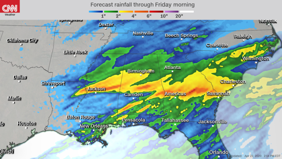
Flooding Is an Additional Threat
The flooding potential will be higher with this round of storms because many of the locations that will see rain are already saturated from the last rain event a few days ago.One to 3 inches of rain per hour is possible across parts of Alabama and Georgia, increasing to 2 to 3 inches per hour across eastern South Carolina.