


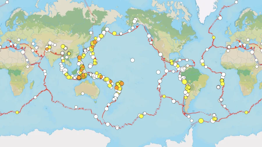
The figures come from two separate USGS measurements. The total of 673 includes every earthquake of magnitude 4.5 or greater worldwide during the past 30 days.
Meanwhile, the agency also identified 14 significant events based on strength, reported shaking, or estimated human and economic effects.
USGS determines whether an earthquake is significant using more than just its magnitude. The agency assigns a score factoring in magnitude, the number and intensity of public reports, and the PAGER alert level.
The most powerful event in the past 30 days was a magnitude 7.7 earthquake near Ende, Indonesia, on Aug. 15. Indonesia’s disaster agency reported at least 100 deaths, more than 1,600 injuries, and damage to over 73,000 homes as of Aug. 24. About 180,000 people were evacuated as thousands of aftershocks followed.
At the time, Indonesia’s meteorology agency detected tsunami waves after the earthquake, including one measuring about 3 feet near Maurole-Ende.
Hours after the Ende earthquake, a magnitude 6.9 quake struck near Pematangsiantar, Indonesia, at a depth of about 109 miles.
Among the other significant earthquakes, the July 28 Kumamoto earthquake in Japan killed 38 people and injured hundreds. Earthquakes in Spain caused property damage and were followed by tremors that injured three people.
Other significant earthquakes included a magnitude 5.6 near Skwentna, Alaska, on Aug. 8; a magnitude 3.9 near Hope, Alaska, on Aug. 22; a magnitude 6.3 near Sarangani in the southern Philippines on Aug. 5; magnitude 5.7 and 5.8 earthquakes in China’s Qinghai province on July 28; and a magnitude 6.3 south of the Kermadec Islands on Aug. 5.
Many recent earthquakes were concentrated around the Pacific, but the 673 events recorded by USGS also included activity in the Atlantic, Mediterranean, Indian Ocean, and other regions.
The largest is the circum-Pacific seismic belt, an area tracing the rim of the Pacific Ocean. About 81 percent of the planet’s largest earthquakes occur along the belt, commonly called the “Ring of Fire.”
The Alpide earthquake belt, extending from Java and Sumatra through the Himalayas and Mediterranean before reaching the Atlantic Ocean, accounts for about 17 percent of the world’s largest earthquakes and has produced some of history’s deadliest disasters, according to the USGS.
A magnitude 7.6 earthquake in Pakistan killed more than 80,000 people in 2005. The magnitude 9.1 Indonesia earthquake in 2004 generated a tsunami that killed more than 230,000 people across countries surrounding the Indian Ocean, USGS states.
The third major earthquake zone traces the Mid-Atlantic Ridge, a vast underwater mountain chain where tectonic plates are pulling apart, while most of the ridge is deep beneath the Atlantic Ocean. Iceland sits atop the ridge and has experienced earthquakes of magnitude 6.9 or higher, according to the USGS.